


Grotte de Montarquis et combe sauvage

michel.pegaz
User
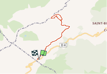

Length
7.9 km

Max alt
2094 m

Uphill gradient
618 m
Km-Effort
16.2 km

Min alt
1614 m

Downhill gradient
617 m
Boucle
Yes
Creation date :
2023-01-22 17:28:46.922
Updated on :
2023-05-14 20:04:08.093
3h40
Difficulty : Difficult

FREE GPS app for hiking
 SityTrail
IGN / Geographical institutes
SityTrail Plus
The world is yours!
About
Trail Walking of 7.9 km to be discovered at Auvergne-Rhône-Alpes, Upper Savoy, Le Reposoir. This trail is proposed by michel.pegaz.
Positioning
Country:
France
Region :
Auvergne-Rhône-Alpes
Department/Province :
Upper Savoy
Municipality :
Le Reposoir
Location:
Unknown
Start:(Dec)
Start:(UTM)
304522 ; 5096279 (32T) N.
Comments